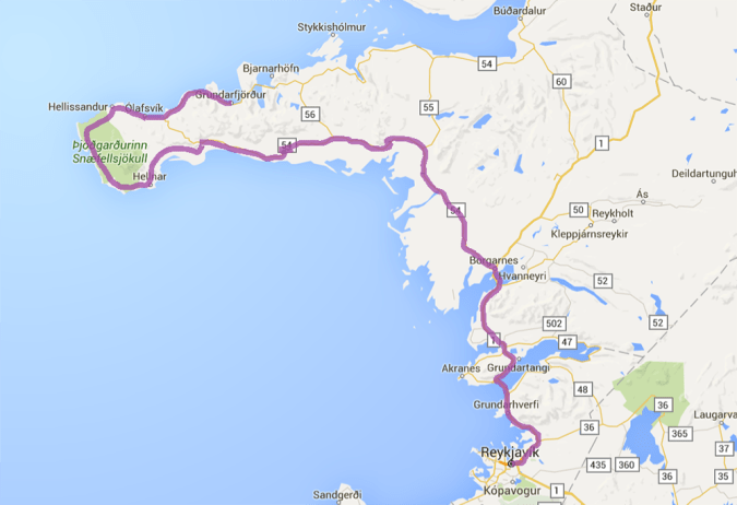
Our fourth day in Iceland, Haider and I planned to visit the Snæfellsnes peninsula, but we woke up late, ill-prepared and feeling a little off. Rather than stress ourselves out trying to cram the day as full as the last few had been, we decided to take our time.
We picked up some groceries and plotted out a few highlights of Snæfellsnes that we wanted to hit, while keeping our schedule decidedly unambitious. We reasoned that it wasn’t worth trying to maximize every second of daylight if we’d only end up irritable and burnt out.
It was okay, because (to quote countless white girl Facebook memes) the real adventure of the day was the journey, not the destination.
It would be our first day traveling on our own, and we realized that we’d been relying pretty heavily on our Couchsurfing companion Raz. Haider’s manual driving skills were still pretty weak, and neither of us had access to data on our phones, as Raz had. Still, it’d been quite easy to navigate the roads to Vik and back, so we didn’t think it would be a problem to drive without GPS. I pulled up Google Maps directions to our first destination, Ytri Tunga Beach, and wrote them down in painstaking detail, complete with landmarks along the way. I took photos on my phone of the map. I listed the kilometers between each turn. So well prepared, right?
Haha.
We screeched and jerked our way down Ryan and Joe’s street, getting deterred again and again by road closings, pedestrians and other cars. After a few stall-outs, we made it to the first street we were to follow, only to reach a dead end where the road was supposed to bend to the right.
Just like that, four blocks from our hosts’ apartment, we were completely lost.
A tense and confusing half hour ensued. We made our way to the only landmark we knew — the iconic church, Hallgrimskirkja — and luckily found a map there. Comparing the map to our notes, we pinpointed the road we should be taking out of town, and worked out how to reach it. Then we got on it the wrong way. We turned around and argued about whether or not we were now going the right direction. Despite our attempts to stay calm and not get angry at each other, we were both frustrated. Haider was stressed out about driving stick and expected me to have all the answers — I’d been the one to write down the directions, after all — and I was flustered by my lack of resources to consult to figure out if we were actually on the right track. Days-old tensions started to flare up. “Remember when I wanted to buy a map, and you said it was too much money?” I spat. “We could really use a map right now!”
Eventually, we found ourselves on the right track, and all anger and frustration was forgotten. It’s amazing how these days, what would have been such a simple task less than a decade ago — finding your way without turn-by-turn directions fed to you by a GPS — becomes such a triumph. We were ridiculously pleased with ourselves just for making it out of the city limits.
The joy turned out to be a bit short-lived. Soon we came to the edge of a fjord, and had to pass through a tunnel requiring a toll. Commence panic, again. We didn’t have any Icelandic kroner on us (everywhere in the country accepts debit cards, so we didn’t want to bother with exchanging currency) and didn’t want to cause a scene as the dumb, entitled Americans that don’t know how to read a sign and expect to drive around a foreign country’s toll roads without bothering to carry their money.
We turned around just before the mouth of a tunnel and retraced our route, stopping at the first building we passed. It looked like a visitor’s center, so we ran up to a man who was walking inside the building — which actually turned out to be a school. I can only imagine how weird and stupid we looked to this poor guy, who barely spoke any English. Flustered, we struggled to even pose our question to him. “The bridge, up ahead, it takes… money?” In his distraction Haider said bridge instead of tunnel, further confusing the dude. But he quickly figured out the cause of our distress, and in typical Icelandic fashion, answered us with the utmost kindness and patience, explaining in his broken English that the toll booth would accept our debit card. “Just put in your card and, em, smile,” he said. “No worries!”
The tunnel itself proved to be much scarier than negotiating the toll dilemma. It’s six kilometers long, going steeply downhill for 3km and then just as steeply uphill for 3km — not an easy journey for someone who’s still mastering the gear shift. It was dimly lit and the walls were made of roughly hewn rock, making us painfully aware of how far we were below a large body of water.
Luckily, the rest of the drive to Snæfellsnes was smooth sailing and great fun. It was nice to be alone in each other’s company after three solid days spent with fellow travelers and new friends. The landscapes were — shocker! — utterly magical. It felt great to be cruising along freely, with nothing on the agenda besides drinking in as much of the natural beauty as we possibly could.


Whenever we felt moved to, we’d pull over on the side of the road to examine yet another astonishing waterfall or snap some photos of the craggy landscape.


We reached Ytri Tunga Beach after a few hours. I’d chosen it as our first destination because it was known as a hangout spot for seals. A British couple was leaving as we arrived, and they told us that the seals were out today and let us know where to find them. We traversed big rocky stretches of boulders to the edge of the shoreline and saw a handful of lumps in the water. Sea puppies!


We had to maintain a solid distance from the seals, and didn’t want to disturb them, so we quietly sat by the edge of the water and watched them. At first we just saw three of them, but after a while realized there were actually eight of them, sunbathing on the shoreline and in the water. We wished that we had thought to bring a pair of binoculars since it was difficult to see them well, but any time one of them would move to change position, we could clearly make out their adorable heads and flippers.

With daylight burning, we left the seal beach and pressed on to Hellnar, just inside Snæfellsnes National Park. We had only a little time to explore before nightfall, so we thought the 2.5 kilometer hike between the villages of Hellnar and Arnastapi would be perfect. Indeed, it was great. The path took us along dramatic shorelines and through rocky, moss-covered lava fields.


At the end, in Arnastapi, we came across a troll-shaped rock sculpture: a monument to Bárður, the mythical half-human, half-ogre guardian of the Snæfellsnes peninsula.


The Hellnar hike was the last stop we were able to make for the day, as the sun began to set shortly after we returned to the car. We were disappointed to not be able to get closer to Snæfellsjökull, the glacier at the heart of the national park, but at least we figured we’d get a good view of it from the road, which winds around the mountain as it follows the peninsula’s outer tip.
I’d read up on Snæfellsjökull in the guide book as we drove, and was intrigued by the lore that surrounds the volcanic, glacier-capped mountain. In Jules Verne’s Journey to the Center of the Earth, the voyagers descend into the volcano to reach the planet’s core. It also plays a big role in certain New Age beliefs, which consider it to be the “heart chakra” of the planet, connected to six other sacred places. And it’s the location of more UFO sightings than anywhere else in the world. I’m certainly a skeptic when it comes to all of these ideas, but I still find them interesting.
Snæfellsjökull did seem to have a feeling of power to it. Though it’s Iceland’s smallest glacier, it appeared profoundly majestic in the brief glimpses we caught of it from the southern coastal road. As we reached it, however, a dense, almost otherworldly fog descended upon the road and the lava-rock landscape. It felt as though the mountain was intentionally shrouding itself from our prying gaze.

The fog also concealed another landmark I was looking forward to — a communications antennae next to the village of Hellissandur that was built by the Americans in the Cold War. Standing over 1,350 feet tall, it’s the tallest structure in Western Europe.
Finally, as we rounded to the peninsula’s northern shore, the fog drifted away to expose the glacier itself. Though we didn’t get to see as much of it as we would have liked, the misty wisps that clung to it made for an even more dramatic view, befitting of its supernatural reputation.

Soon afterward we reached our accommodation for the night: an adorable guesthouse in lovely Grundarfjörður, situated between the mountain peaks and the sea.
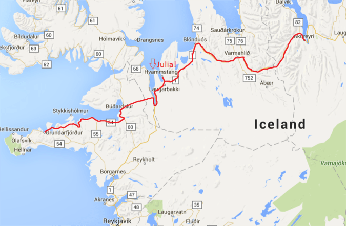
In the morning we hit the road again, hoping to make it to the northern town of Akureyri by afternoon. Along the way, we’d made arrangements to pick up a German couchsurfer named Julia in Hvammstangi, which was about two and a half hours away according to Google Maps.
Determined not to repeat the mistakes made in navigating out of Reykjavik, I pored over every line of the directions, committing the name of each route to memory. Route 54 until well past Stykkishólmur. Route 60 to Búðardalur. Route 59 inland. Route 1 at the tip of the fjord.
Considering that there are only a handful of roads in this section of the country, I saw no way for this part of the journey to go wrong. We cruised along merrily for the better part of an hour, making much better time than I’d anticipated.
Just as expected, we came upon a sign telling us to take a right to stay on Route 54 toward Búðardalur and Akureyri, exactly where we were headed. But this road was nothing more than a gravelly dirt path through vast, empty fields.
Surely, we reasoned, there’s no way that a major road connecting this area’s most populous towns would be nothing more than a line of dirt? We bailed on our directions and turned around to follow the proper asphalt road — which came to an abrupt end at the ocean about 10 minutes later. A very kind lady at a tourist office informed us that we had two choices: retrace a great deal of the way we’d driven, then go an hour or two out of the way south to stay on paved roads, or take the dirt road. She encouraged us to try the dirt road. “It’s very beautiful!”
Between the Sad Car and Haider’s manual skills, we were very doubtful, but going so far out of the way sounded terrible. We pressed on. It wasn’t so bad. “Now it’s a real adventure!” we told ourselves.
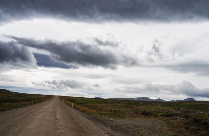
But all the same, the road was bumpy and rough and speckled with potholes. We had to drive slowly and were already way behind schedule, with no way of contacting the German girl who was waiting for us. And we had no idea how long we’d be in this backcountry for.
So when we finally reached blessed pavement again, we were pretty stoked.


Until literally about 2 kilometers later, when the asphalt immediately gave way to another solid hour of dirt roads.
We couldn’t even find any towns along the way with a cafe that we might access wifi from to contact Julia, so when we finally arrived in Hvammstangi nearly three hours late, we had no idea if she’d still be there. “Do you even know what she looks like?” Haider asked as I leapt out of the car to look for her.
Luckily, it didn’t matter. Immediately, a brunette girl with a giant backpack called out a friendly “Hello!” and headed over to the car. She was outside and suited up with her gear because she’d just decided to give up and try to hitchhike up to Akureyri, sure that we must have either had some sort of accident or just ditched her. Right as she began walking up toward the main road, she saw us pull in.
The rest of the way to Akureyri was uneventful — as uneventful as driving through gorgeous, lush mountainscapes while getting to know a cool fellow traveler can be.


Once we arrived in town, we checked into the backpacker’s hostel, grabbed some dinner and settled in for a night hanging out with fun and interesting people from all over the globe. We barely even saw the town — after two solid days of driving, and with big plans to explore the northern country the following day, it felt great to just hang out and enjoy the company (set to the aggressively festive tunes of a lederhosen-clad accordion player for the hostel’s Oktoberfest night).


I am loving your blog. This land could be my land!!
LikeLike